Parque Nacional do Itatiaia Picture 7
More information on Parque Nacional do Itatiaia Photo by: Rodolfo Magalhaes
Parque Nacional do Itatiaia
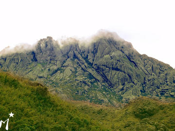
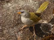
The Itatiaia National Park is the oldest national park in Brazil, founded on June 14, 1937, by then president Getulio Vargas through the Federal Decree No. 1713, with a current area of 30,000 hectares (300 km2). The park has mountains with nearly 3,000 feet high and has a very diverse fauna and flora due to altitude and climate varied. It is administered by the Chico Mendes Institute for Biodiversity Conservation (ICMBio).
The name is Tupi Itatiaia means "cliff full of tips. "
During the Brazilian winter, the months of July and August, the temperature decreases too much and rainfall as well, leaving the dry climate and very cold. Consequently, a country with almost 93% of the area located in the tropical zone, there may be phenomena such as frost on the fields and plants of the park and the snowfalls of more stringent on the days of the site.
Bridal Veil Falls
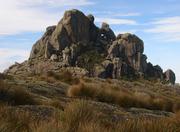
Pico das Agulhas Negras
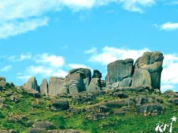
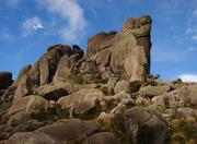
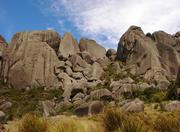
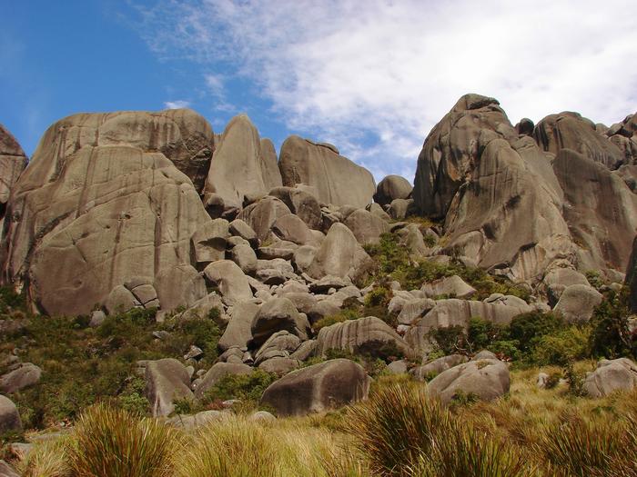
Massif of Shelves
* Blue Lagoon, a natural lake formed by the river Campo Belo, which is approximately 500 m from the Visitors Center.
* Waterfall Poranga (in Tupi, poranga means beauty), is a waterfall with 10 meters of waterfall and a large natural pool formed by the river Campo Belo.
* Maromba Waterfall, waterfall and large pond.
* Itaporani Waterfall, waterfall and natural swimming pool.
* Bridal Veil Falls, waterfall formed by river Maromba forming a waterfall 40 meters high, is at 1,100 meters altitude.
* Three peaks, place the middle of the Atlantic at 1,662 meters above sea level, overlooking the valley of the Paraiba, of Mantiqueira and Serra do Mar.
* Stone Foundation, is located on the roadside, opposite the access gate.
* Belvedere Last Goodbye, panoramic view of the river valley Campo Belo and Serra do Mar.
In the upper region of the Itatiaia Plateau, are the high altitude grasslands, and its high points
* Peak Itatiaiaçu located on the Agulhas Negras to 2791.55 meters above sea level.
* The peak of the Couto second highest point of the park with 2680.99 meters above sea level.
* The Mountain of Maromba with 2607 meters of altitude.
* The Shelves with 2548 meters of altitude formed by massive blocks of rock overlooking the Vale do Paraiba. Next to the shelves there are several lakes and rock formations like the Turtle Rock, the Rock and apple Seated Stone.
* The Altar Stone is a rock formation with 2530 meters of altitude.
* The Two Brothers with 2,500 meters of altitude.
* The Lion's Head with 2408 meters of altitude.
Plateau is part of the Valley Aiuruoca, with waterfall and rock formation of Aiuruoca Chicken Eggs. On the way can be seen the rock formations of Hermes and Asa Stone Altar.
Is geographically located between latitude 22 º 19 'and 22 º 45' south latitude and longitudes 44 º 15 'and 44 º 50' west longitude.
The park is located in the Itatiaia massif, in the Mountain range on the border between the states of Rio de Janeiro and Minas Gerais. It is located in the southern state of Rio de Janeiro, in the municipalities of Itatiaia and Resende, and the southern state of Minas Gerais, covering the municipalities of Itamonte (MG), Alagoa (MG) and Bocaina de Minas (MG).
The park is located on the highest road in Brazil, as it reaches 2450 m altitude.
More Photos of Parque Nacional do Itatiaia Picture 7