Ilha do Arvoredo Picture 1
More information on Ilha do Arvoredo Photo by: Daniel Filgueiras
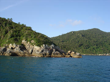
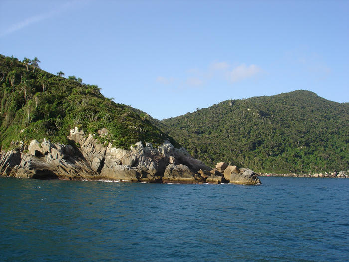
Ilha do Arvoredo
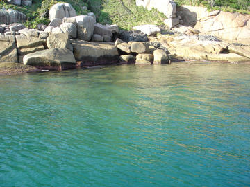
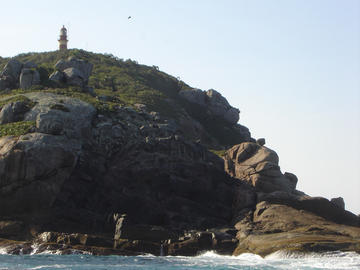
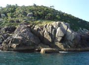
Breathing the air when disembarking on Arvoredo Island is invigorating to our senses weakened by the civilization. We can notice how tiny we are before the forces of nature. The wave rhythmic sound against the rocks is sheer poetry and we find ouservelsve staring at that beauty in the raw. Diving in the clear and and full-of-fish waters of one of those islands, which form the Reserva Biológica Marinha do Arvoredo (Marine Biological Preserve of Arvoredo Island), located 11 kilometers to the north of Santa Catarina Island, definitely solidifies the sensation of enchantment on the visitor's soul. Arvoredo is a pretty very important island. It was and has been a natural shelter for the navigators in the far sea. The island is large and has high hills. The bays, with calm waters, protects the island from hard blowing winds. The north bay is protected from the southeast wind which blows in the winter. Capim bay, in the southwest, is protected from the northeast wind which blows mostly in the summer. The 24 mile-reach beacon is used as a compass. Arvoredo Island is a reference spot for the navigation in the southern seas. And it's the best fishing ground of the region. Fishermen, divers and navigators revere the island. The island is always monumental, either for its shelter, for the moments of contemplation of the clear waters or the steep bays...or for any other reason or viewpoint.
Biological frontier
One of the only two marine biological preserves of the country,despite the 8 thousand kilometers of the Brasilian coast - the other one is the Atol das Rocas (Rocas Atoll), in Rio Grande do Norte - the Arvoredo preserve consists of 17,800 hectacres (43,983 acres) distributed among Arvoredo, Galé and Deserta Islands and São Pedro flintstone (fragment of hard rock) and all over the surrounding sea coast.
Arvoredo Island has a special characteristic. It's a borderline between the Tropical and Subtropical regions, a climatic and biological crossing line. There, the Brazilian Current, coming from the north, the clear and hot waters meet the polar water Falklands Current conveying great amount of nutrients. As a result, tropical fish cope with southern chilly water fish, like penguins and whales. The fauna is exuberant. Pink shrimp, squibs, lobsters, octopuses, groupers and hundreds of other species drift before the divers. Without this breeding ground, the groupers, for instance, whose sex definition takes three years and consequently to start procreation, would turn into endangered species in the region. Sea birds like royal terns, "fragata", "atobá" and the seagull live and breed on the preserve islands, which in turn are a safe place for the migratory birds to rest. Penguins, turtles, whales and dolfphins are another occasional visitors of that area, chosen due to its quietness and isolation.
Rock engravings
Besides the rich fauna the preserve has other treasures. Arvoredo Island, the largest one, preserves 270 hectares (667 acres) of the Atlantic Forest. The "gerivá" coconut tree is the badge of this local flora. Besides the exuberant native forest, intriguing rock engravings are all over the island rocky cliffs. Known as "itacoatiaras" they are undoubtful signs that the prehistoric man had been there, where he also left lithic workshops (places on the rocks to manufacture tools) and archeological sites like "sambaqui" (prehistoric deposits of sea shells, kitchen refuse and skeletons found on the coast).
All these characteristics make Arvoredo Island a special place for the region. In the early 80's this ecological diversity inspired environmentalists to press on the public authorities to create a preserve there.
The man's interference
Since 1750, when the azorian immigrants who settled on the Catarinense coast found out that the water was fish abundant, craft and industrial fishing has taken place. In the last two decades the underwater fishing and the fishing at the cliffs have also contributed to the drastic decrease of big fish, crustaceans and molluscs of trade interest.
All those facts caused damage to the records left by the historic populations of the island - some sambaquis (prehistoric deposits of shells, kitchen refuse and skeletons found on the coast ) were damaged by the construction of fishing shelters. Another agression, the collection of eggs from marine birds in breeding period, became common among the visitors.
The preserve creation
The creation of the Arvoredo Marine Biological Preserve took place in March of 1990, through the decree number 99,142. IBAMA chose this management category after evaluating on site the increasing environmental damages which the area was exposed to. Preserve is the most restrictive environmental management category, which prohibits the access to the area without authorization.The other categories are parks - where the visitations are regulated but allowed -, APAs (environmental preserve ), RPPNs (private preserves of the natural asset ) and other types with fewer restrictions. The choice of preserve is yet contested by the nearby population and diving companies.
To compensate the access restriction, the IBAMA, from 1997, has done its best to get a bigger interaction with the community through pilot-projects of observational diving. In addition IBAMA has established environmental education as an extra-curricular subject at the municipal schools. The observational diving will make possible to regularize the exploration of the sea tour at the preserve, forbidden since 1994.
In partnership with FACIMAR (Faculdade de Ciências do Mar - Marine Science College, in Itajaí), IBAMA also has an environmental education program in 44 schools of the preserve six bordering cities - Florianópolis,Governador Celso Ramos, Tijucas, Porto Belo, Bombinhas and Itapema. They are basically fishermen's children who have lessons about the preserve in Geography classes, write compositions about the environment in Portuguese, learn about the deforestation of Atlantic Forest in History classes. The flora and fauna of the region are taught in Biology classes.
Data base
These projects were just made possible due to a precious base - a detailed data base which IBAMA started to build in December of 1994, which nowadays is an international reference. Through this data base, it's possible to access from a computer each one of the 458 fauna and flora specimens in the preserve. The records reveal whether they are residents in the area or just passers-by in a migratory process, if they are endangered species, their eating habits and predators. The records also contains a physical description of the species, colorful pictures and also maps and illustrations about the region.
Through the data base you can know in detail all the human activities in the area - fishing, diving, landing on the islands (which is forbidden), passing-by traffic to other places and rides. The researchers even know the depth in which every kind of fishing technique takes place and the percentage of refuse (unwanted fish).
Model work
This asset is a result of hard surveillance months in the sea and on the islands, many hours of diving, talks with the fishermen and also an oceanographic cruise on the research ship Diadorim, from FACIMAR, besides exhaustive bibliographic researches. The monitors have registered 336 boats that came through the preserve, and sorted them out according to the number of crew members, origin, owner, fishing and diving gear and the type of fish. It was worth the effort. Besides making the fishermen aware of the preserve importance for repopulating the marine species in the region, the oceanographers ended up developing a pioneer project to monitor and handle the data in the country's preserves.
More Photos of Ilha do Arvoredo Picture 1