Presidente Figueiredo - a Terra das Cachoeiras Picture 1

More information on Presidente Figueiredo - Trilha para Cachoeira in Manaus Photo by: mustafajr
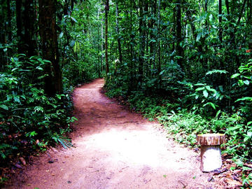
Presidente Figueiredo - Trilha para Cachoeira in Manaus
Presidente Figueiredo Presidente Figueiredo, located 107 km north of Manaus, is one of the few cities which can be reached by car from the capital. After little more than an hour and a half driving through the BR-174 (connecting Manaus to Boa Vista and also in Venezuela), you'll arrive at the city. It's known as the Land of Waterfalls, because there are more than 100 waterfalls of various sizes and several rapids, caves and caverns, which provides plenty of activities like rafting, kayaking, zip line, rappelling, caving, tree climbing and trekking through jungle trails.
The city itself until it is quite structured, considering we're talking about a small town. There are several regional restaurants around the city and a very good offer of inns and small hotels which, although simple, are very comfortable. Unlike the typical hotel in the jungle region, the prices are fair and fit the budget of any tourist. The Tourist Service Centre (CAT), located just off the entrance to the city, is a great source of information for visitors. Displaying several pictures of the natural beauty of the region, the site is organized and has a team trained and instructed to give all necessary information on what to see and do in Presidente Figueiredo. An evening there is more than recommended before starting any trip. Do not forget to inquire about hiring guides (which are not expensive) and get a small map with the location of all the attractions of the city.
Also noteworthy is that the small town is a very nice place because of its location in a preserved area of rugged terrain. Thus, it becomes possible to see virtually any part of the city skyline dominated by the forest, which, in the early hours of the day, it's covered by a thin mist, forming a lovely setting. There are also towering walls of rock, roots and leaves that spread all around and the waterfalls and caves of President Figueiredo.
You will not find the typical scenario with heavenly blue water pools surrounded by colorful flowers, but a unique environment whose beauty and charm comes from its natural wild appearance and the feeling of isolation it imposes. Surrounded only by ancient sandstone rocks and the intense green of the trees, the feeling is like being lost in a small oasis in the midst of the largest forest in the world. Despite the massive influx of tourists in Manaus on the weekends, most of the natural beauty of Presidente Figueiredo remains unknown to the general public. Only five or six waterfalls are visited frequently, and there are several caves and rapids that can be heard from a long distance.
Attractions:
Waterfalls: Lages. Location: On the right side of the highway BR 174, Km 113, 4 waterfalls distributed in 1,500 m in track in the forest. Pedra Lascada. Location: On the right side of the highway BR 174, Km 113, the 1,700 m in track in the forest. Iracema. Location: On the left side of the highway BR 174, Km 115, 400 m in branch empiçarrado. Araras. Location: 1500 m after Iracema waterfall, a trail inside the forest, within the area of Iracema Waterfall. Surframa. Location: On the right side of the highway BR-174, Km 96, 200 m in track in the forest interior. Santuario. Location: On the right side of the AM-240 highway, access the Balbina Km 12, 1. 200 m in the forest.
Rapids:
Urubui. Location: On the left side of the highway BR 174, Km 107, 300 m from the main road. Barreto/Balneario Barreto. Location: On the right side of the AM-240 highway, access the Balbina Km 65. Santa Barbara. Location: Located at Km 9 Urubuí's extension, 300 m. on track inside the forest. Santa Lucia. Location: On the left side of the highway BR-174, Km 113, 50 m. Panorama. Location: On the left side of the highway BR-174, Km 109, 300 m in track in the jungle. Balneario. Location: On the right side of Highway AM-240, access the Balbina 12 km, 100 meters in track. Uirapuru. Location: On the left side of Highway AM-240, access the Balbina Km 32, 3 km extension empiçarrado, and walk along the trail.
Caves:
Refuge Maroaga. Location: On the right side of the AM-240 highway, access the Balbina 6 km, 600 m in track. Iracema. Location: On the left side of the highway BR-174, Km 115, at 4000 m. extension inward to Iracema Farm. Within the area of Iracema Waterfall. Araras. Location: at 1500 m. after Iracema Waterfall on trail along the Rio Urubuí.
Festivals: Feast Cupuaçu and Agribusiness Exhibition (19-21 April), Folk Festival (26-28 July), Festival of the Sun (6-8 September), Feast of the Patroness of the City (October 12), Peacock Bass Fishing Tournament (Oct. 12), Anniversary of the City (9 and 10 November).
CAT - Presidente Figueiredo BR-174, Km 107, s / n - Center (behind the Church Hall)
Phone: +55 (92) 3324-1308
Distance from Manaus: 107 km
Getting there: Bus (2 hours / 17 dollars). With own car, follow the BR-174.
Centers Tourists Services (CAT) and the River Terminal rental (TFT) act as information centers and services to visitors, with bilingual attendants that provide information about domestic and international flights, ground transportation companies, travel agencies, hotels, restaurants, nightclubs and tourist spots, and general information about the city.
Presidente Figueiredo´s Center Tourist Service (CAT) BR-174, Km 107, s / n - Center (behind the Church Hall)
Phone: +55 (92) 3324-1308 http://www.viverde.com.br/figueiredo.html http://descobrindooamazonas.webs.com/presidentefigueiredo.htm
More Photos of Presidente Figueiredo - a Terra das Cachoeiras Picture 1