Parque Nacional de Aparados da Serra Picture 1
More information on Parque Nacional de Aparados da Serra Photo by: CasalMALY
Parque Nacional de Aparados da Serra
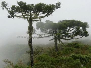
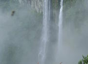
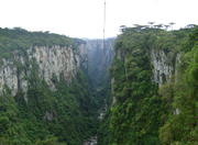
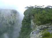
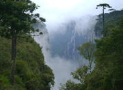
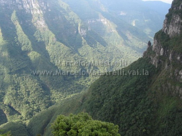
Deep valleys, with up to 900m high, lined with pines. Its edges waterfalls plummet up to 720m. Cold and damp and the fog that surrounds these formations are likely to enjoy a true mate. This is the scenario where the five largest canyons in the country. A spectacular landscape threatened by deforestation of Araucaria even though a region of environmental preservation. His creation is old: 1959. The oldest are the canyons that began forming 130 million years. Enriching sections of the landscape are Araucaria Forest almost extinct. This is rather to be found within the 10,250 hectares of National Park of Sierra Aparados. Cultural and historical aspects The Park is two distinct cultures: on the plateau and the lower part.
The plateau had colonization of the Jesuits and the presence of foreigners as Germans and Italians. Natural features A stroke of lava 130 million years ago spread across the surface in the form of crust. This crust cracked in half, forming sharp edges that seem to have been carved. Thus came the canyons of the region, having an average depth of 600m. The fog that often surrounds these formations is due to the large temperature difference. The flora of the park consists of patches of Araucaria Forest, the Atlantic rain forest and fields. Its main representatives are, respectively, the Parana pine, grasses and herbs, and large trees as cangerana. Among the mammals that constitute the fauna are the puma, maned wolf, the pampas deer and graxaim.
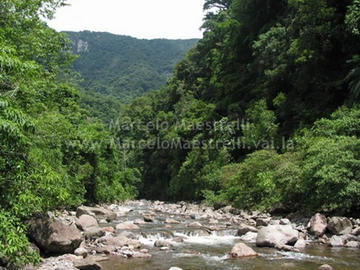
The park is home to three species of endangered birds: the duck-hawk, the hawk-eagle-eagle and the gray monkey. Besides these, there are several species of reptiles. Climate The climate is determined as temperate, with an annual average of 16 degrees, the warmest month is January and the coldest are June and July. Attractions The largest canyon in the park is Itaimbezinho with 5.8 km long. Trails lead up to its edges and from there on a clear day, you can have a view up the coast of Rio Grande do Sul. The more adventurous can follow trails that lead to the valley of the rivers. An eight hour walk to the Vale do Rio do Boi, leads to a place known as the Cross, where you see one of the curves formed by cracks in the mountain. Waterfalls tumble from the edges of the canyons. The most famous is the Bridal Veil with 720m high. In addition, observe the rare Araucaria Forest and endangered animals can be a good experience.
The park has a visitor center, a cultural space for exhibition of photographs, an auditorium with capacity for 50 people, cafeteria, health, handicraft shop and parking. Specific Objectives Conserve significant sample of vegetation on the drive, and protect geological and geomorphological aspects of the area.
The Parque Nacional Aparados da Serra is located on the border between Santa Catarina and Rio Grande do Sul, belonging to the cities of Praia Grande (SC) and Cambará do Sul (RS). Access To get there, from Porto Alegre, take the RS-020 toward San Francisco de Paula and Cambara From South of Santa Catarina, you can take the BR-101 to Praia Grande.
http://ecoviagem.uol.com.br/brasil/rio-grande-do-sul/parque-nacional/aparados-da-serra/
More Photos of Parque Nacional de Aparados da Serra Picture 1