| Anhatomirim Island - MAP 3 Anhatomirim IslandAnhatomirim Island (Indian name) is located in North Bay, near the continent and now part of the municipality of Governador Celso Ramos.Its strategic position - at the entrance of the North Bay - was responsible for building the Fortress of Santa Cruz in the eighteenth century, setting the third vertex of a triangular system of defense, has formed the Fortress of São José da Ponta Grossa and St. Anthony of Mice. This... |
 Antiga Alfândega - MAP The history of the Old Customs House began in 1874 when John Thomas Doe, president of the Province of Santa Catarina, was authorized to order the building of a new headquarters to replace the previous one burned down in 1866 for reasons still unknown. The venue was not the same as the previous building, but in the marinas, the streets of Deliverance and the Ombudsman, then place called Largo Prince, by staying on the street of the same ... Antiga Alfândega - MAP The history of the Old Customs House began in 1874 when John Thomas Doe, president of the Province of Santa Catarina, was authorized to order the building of a new headquarters to replace the previous one burned down in 1866 for reasons still unknown. The venue was not the same as the previous building, but in the marinas, the streets of Deliverance and the Ombudsman, then place called Largo Prince, by staying on the street of the same ... |
| Casario da Rua Menino Deus - MAP Houses of Rua Menino Deus
On the streets Bulcão Vianna and Baby Jesus, near the slopes of Charity Hospital, focuses on a low houses, typical of colonial occupation.
They are houses, built on land narrower and longer. Maintain the characteristic rhythm of doors and windows on the main facade and pitched roof.
At the corner of Avenida Mauro Ramos is a nineteenth century manor house, with windows framed in stone, very rare occ... |
| Eighteenth Century Mansions - MAP The row houses on Rua Fernando Machado on the 16 and the Praça XV de Novembro 352, 348, 344 and 340 maintain the aesthetic character of the Luso-Brazilian architecture, combining the alignments of the doors and windows, glazing the flags, the railings of the balconies decorated, and high-reliefs by weight of eclectic inspiration, in the fronts. Two terraced houses still remain in the back of the lots, their historical gardens, typical ... |
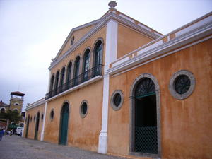
| Fortaleza de Nossa Senhora da Conceição - MAP Fort Fortaleza de Nossa Senhora da Conceição built in 1742.
The Fortress of Nossa Senhora da Conceição de Araçatuba was the fourth and last of the Portuguese fortresses devised by Brigadier José da Silva Paes.
Built in the Isle of Araçatuba, between the years 1742 and 1744, the fortress was the only intended to protect the entrance of the South Bay of Ilha de Santa Catarina. He also served in prison on several occasions, i... |
| Fortaleza de Santa Cruz - Anhatomirim - MAP 3 The Fortress of Santa Cruz, located on the island of Anhatomirim, was the main fortification of the old defensive system of the island of Santa Catarina, designed and built by Brig Portuguese José da Silva Paes from 1739. This system was also composed by the strength of Sao Jose da Ponta Grossa, Santo Antônio de Ratones and Nossa Senhora da Conceição de Araçatuba.Belonging to the Navy Department, the Fort Anhatomirim was listed in ... |
| Fortaleza de Santo Antônio - MAP 5
In 1938 the Fortaleza de Santo Antônio de Ratones was listed by the National Historical and Artistic Heritage. In 1991 its many buildings were restored and the Federal University of Santa Catarina is now managing the fortress, making it a most beautiful and unique tourist attraction.
Fortaleza (Fortress) de Santo Antônio de Ratones, built in 1740, is situated in the northern part of Ratones Grande Island, o... |
| Fortaleza Santana - MAP
Santana's Fort was built from 1761, designed by the military engineer José Custódio de Sá e Faria. Being situated along the strait of the union of North and South Bays, its function was to protect the Town of Our Lady of Desterro, presently Florianópolis, from vessels that enter the North Bay. Later this protection was reinforced with cross-fires with the St. John Fort, located on the mainland opposite... |
| Fortaleza São José da Ponta Grossa - MAP
Built in 1740, with the task of defending the North Bay of the island of Santa Catarina, along with the Fortress Anhatomirim and Fortaleza de Santo Antonio, the Fortress of São José da Ponta Grossa had in the XVIII century, three batteries of cannons armed with 31 pieces of artillery. Those three Fortress controlled craft that reached the coastline of Santa Catarina, which was halfway between the port of Rio de Janeiro ... |
| Forte Santa Bárbara - MAP The Fort was built in the second half of the eighteenth century with bricks and stones on a rocky islet near the beach. But in the early twentieth century involved the landfill island, linking it to the island of Santa Catarina.
The fort was intended to prevent the passage of pirates through the channel of the Straits and protect the ancient town of Nossa Senhora do Desterro. Due to its location, right in the center of the capital, h... |
| Memorial do Centro Educacional Menino Jesus - MAP The Memorial CEMJ, created by Decree No. 26 of 04.08.2005 of the Association of Franciscan Sisters of St. Joseph, is proposing the projects of the culture incentive laws, the Association of Parents and Teachers of the Educational Center Child Jesus. The organization and installation of memorial activities resulting CEMJ and were conducted by a committee appointed for that purpose under the coordination of Sister Oneide Barbosa Coelho.
... |
| Old Town Hall - MAP The old Town Hall and Jail was built between 1771 and 1780 with funds from the payment of taxes called quaint "literary subsidy", which were collected on each barrel of rum. The chain was on the ground, as determined the Portuguese tradition, and ran upstairs to the Legislative Assembly and the Provincial Palace House and Senate.
The Luso-Brazilian sobradão was changing with a number of reforms, to incorporate in 1896, with some ec... |
| Ribeirão da Ilha - MAP
Ribeirão da Ilha is ideal for: hiking, leisure, food, visits to historical heritage. Situated in the South Bay on the island, 27 km away from downtown, the district of Ribeirão da Ilha was the first European community of Florianópolis. Historians date the arrival in 1506 of the first European navigators to the site, and in the eighteenth century its population effectively.
The many small beaches in... |
| Engenho Caminho dos Açores - MAP This ingenuity of the nineteenth century, the family of Agenor de Andrade, was listed on the initiative of his own family, as well as of historical interest.
Ingenuity of the Azores, a rammed earth construction, preserves all stages of craft production of cassava flour. In several of these steps was necessary to use the strength of the ox and the work of Sevare, rolling, drying, roasting and storing flour, was divided between the fa... |
| Praça Fernando Machado - MAP Fernando Machado Square
Located in front of the Praça XV de Novembro, was held the first Public Market and the model of the bridge which served to light Hercílio the symbolic inauguration of the work. Fernando Machado was in the square that was the Miramar, municipal pier and famous meeting point of the city's intellectual elite, who disappeared with the landfill at South Bay.
Recently, the square has undergone a makeover that ... |