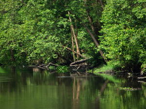
 Ecologico do Cocó Park - MAP 4
The city's largest green area, near the Iguatemi-mall. No lawns, but a nice walk in the woods. It is a conservation area, a natural life state park in the city of Fortaleza, Ceará. It is named after the river that forms the mangrove biome, the Cocó River.
In Sierra Aratanha, Pacatuba city rises the Pacatuba creek, which is called Hawk Creek a bit ahead. Only after the 4th Road Ring in the A... Ecologico do Cocó Park - MAP 4
The city's largest green area, near the Iguatemi-mall. No lawns, but a nice walk in the woods. It is a conservation area, a natural life state park in the city of Fortaleza, Ceará. It is named after the river that forms the mangrove biome, the Cocó River.
In Sierra Aratanha, Pacatuba city rises the Pacatuba creek, which is called Hawk Creek a bit ahead. Only after the 4th Road Ring in the A... |
| Estação Ecoturística Parque das Andréas - MAP 4 Formed by an extraordinary set of waterfalls and natural pools, whose sources are situated on the crest of the Sierra Aratanha.
Andreas Park is one of the several Pacatuba natural attractions, 20 km from Fortaleza. Andreas Park Station ecotourism
With an area of 42,687.30 square meters, is an ecological heritage that preserves one of the most beautiful ecosystems of the Metropolitan Region of Fortaleza.
Located in Carlos ... |
| Parque Estadual Marinho da Pedra da Risca do Meio - MAP 4
The Marine State Park of the Pedra da Risca do Meio is the only Marine Conservation Unit of the State of Ceará, with an area of 33.20 square kilometers distant 10 nautical miles (approximately 18.5 km) from Port of Mucuripe, Fortaleza. Access to this conservation area can only be done by vessels leaving the Port of Mucuripe take on average 50 minutes to reach the Marine Park area.
The creation of the Marin... |
| Parque Nacional de Jericoacoara - MAP 4 Jericoacoara National Park is located in the municipalities of Jijoca Jericoacoara, Camocim Cross and, on the west coast of Ceará, Brazil. It has an area of 8850.00 (ha). The perimeter of the park is 49,929.4 meters. It is administered by the Chico Mendes Institute for Biodiversity Conservation.
Until 1985 Jericoacoara was just a small fishing village, lost among dunes and isolated from the rest of the world. Until the tourism dis... |
| Parque Nacional de Ubajara - MAP 4 In the city of Ceará is located Ubajara the smallest national park in Brazil. Ubajara National Park was created in 1959 to protect samples of savanna and tropical forest in the interior of Ceará, and caves and caverns.
The place gets its name because of the cave Ubajara, the main tourist attraction of the place. The region offers a very pleasant climate and plenty of green area with lush vegetation. Ideal for those who want a more ... |
| Reserva Ecológica de Sapiranga - MAP 4
The area of environmental protection is spread over 600 acres of rain forest, offering tracks which can be explored on foot, bicycle or on horseback, always in the company of biologists. The highlights are the native species of flora and fauna of the region, such as anteaters, monkeys, orchids, bromeliads and gameleiras, and bathing in the river Pojuca.
The Nilva Maria Alves Foundation maintains the largest urban ecologica... |
| São Gonçalo do Amarante Botanical Garden - 4 Besides the various green areas of Fortaleza, commonly frequented by locals, as the Ecological Park of Rio Coco, Fortaleza also has a botanical garden, in São Gonçalo do Amarante, 45 km from the center.
The area of 19.8 hectares is a project of landscaped architect Ricardo Marinho, a disciple of Burle Marx.
At the entrance of the Garden is the administration building with an auditorium, a library, gallery, information cent... |
| Serra de Baturité - MAP 4
To get an idea of the extent of tourist flow in the hills of Baturité just say that since the beginning of the year there was practically no more room in the hotel network for the Carnival. Although the occupancy rate is high almost throughout the year, demand has become more intense due to Jazz and Blues Festival to be held 24-27 February in Guaramiranga. The beauty of the landscape and cultural effervescence is achievi... |
| Serra de Guaramiranga - MAP 4
The Guaramiranga Sierra is located in Baturité Massif, 865 meters high, and its main attraction is the Pico Alto (High Peak), highest point of Ceará, with 1,115 m. The temperature ranges between 12 and 15, and at the place we have a broad view of the interior and the sea. The range of 0.1% of Atlantic Forest still existing in Ceará is in Guaramiranga and transformed into an environmental protection area (APA... |